![](/images/other/stat-length.png)
![Excursión Senderismo La Tour-d'Auvergne - Chambourguet - Photo](https://media.geolcdn.com/t/1900/400/ext.pjpeg?maxdim=2&url=https%3A%2F%2Fservices.sitytrail.com%2FGeolivesWS%2FDownloadMedia.ashx%3FTrailID%3D103398%26Media%3D5480_2.jpg)
Chambourguet
tracegps
Usuario
![Longitud](/images/other/stat-length.png)
Longitud
17,8 km
![Altitud máxima](https://static1.geolcdn.com/siteimages/upload/files/1508320355ic_sort_altitude_max_24dp.png)
Altitud máxima
1265 m
![Desnivel positivo](https://static1.geolcdn.com/siteimages/upload/files/1508320355ic_sort_den_pos_24dp.png)
Desnivel positivo
414 m
![Km-Effort](/images/other/stat-length.png)
Km-Effort
23 km
![Altitud mínima](https://static1.geolcdn.com/siteimages/upload/files/1508320355ic_sort_altitude_min_24dp.png)
Altitud mínima
926 m
![Desnivel negativo](https://static1.geolcdn.com/siteimages/upload/files/1508320355ic_sort_den_neg_24dp.png)
Desnivel negativo
415 m
![Boucle](https://static1.geolcdn.com/siteimages/upload/files/16400158638029165_repeat_loop_refresh_sync_direction_icon.png)
Boucle
Sí
Fecha de creación :
2014-12-10 00:00:00.0
Última modificación :
2014-12-10 00:00:00.0
![Senderismo](https://static1.geolcdn.com/sitytour/trail-icons/101.png)
5h00
Dificultad : Muy difícil
![Escanee este código QR para abrir la excursión en la aplicación SityTrail](https://capi.geolives.com/qq0zvz2zws4bq2lad0pu/sitytour/trails/103398/qr.png?size=200)
Aplicación GPS de excursión GRATIS
A propósito
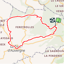
Ruta Senderismo de 17,8 km a descubrir en Auvergne-Rhône-Alpes, Puy-de-Dôme, La Tour-d'Auvergne. Esta ruta ha sido propuesta por tracegps.
Descripción
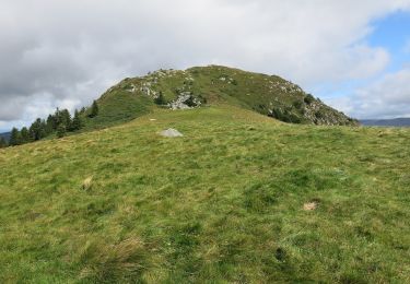
Depuis La Tour d'Auvergne à 945 mètres d'altitude, l'itinéraire progresse jusqu'aux estives à 1265 mètres et conduit au bois de La Charbonnière, site bien connu des amateurs de ski de fond et raquettes en hiver.
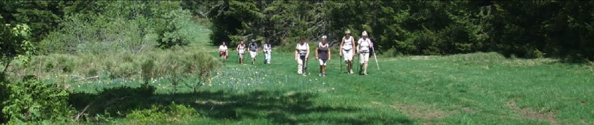
Localización
País:
France
Región :
Auvergne-Rhône-Alpes
Departamento/provincia :
Puy-de-Dôme
Municipio :
La Tour-d'Auvergne
Localidad:
Unknown
Salida:(Dec)
Salida:(UTM)
479955 ; 5044582 (31T) N.
Comentarios
Excursiones cerca
![Excursión Senderismo La Tour-d'Auvergne - Tour_Auvergne_Chambourguet - Photo](https://media.geolcdn.com/t/375/260/89f1026c-dcfd-4eec-ac48-a164d692d4ad.jpg&format=jpg&maxdim=2)
![Senderismo Senderismo](https://static1.geolcdn.com/sitytour/trail-icons/101.png)
Tour_Auvergne_Chambourguet
Senderismo
Difícil
(1)
La Tour-d'Auvergne,
Auvergne-Rhône-Alpes,
Puy-de-Dôme,
France
![](/images/other/stat-length.png)
17,7 km | 24 km-effort
5h 0min
![](https://static1.geolcdn.com/siteimages/upload/files/16400158638029165_repeat_loop_refresh_sync_direction_icon.png)
Sí
![Excursión Senderismo La Bourboule - Bourboule_Vendeix_Charlannes - Photo](https://media.geolcdn.com/t/375/260/974b84fb-245b-4e5c-88f2-976a8059b2eb.jpg&format=jpg&maxdim=2)
![Senderismo Senderismo](https://static1.geolcdn.com/sitytour/trail-icons/101.png)
Bourboule_Vendeix_Charlannes
Senderismo
Difícil
(1)
La Bourboule,
Auvergne-Rhône-Alpes,
Puy-de-Dôme,
France
![](/images/other/stat-length.png)
15,4 km | 25 km-effort
4h 30min
![](https://static1.geolcdn.com/siteimages/upload/files/16400158638029165_repeat_loop_refresh_sync_direction_icon.png)
Sí
![Excursión Senderismo Chastreix - Chastreix. cascades et tourbières - Photo](https://media.geolcdn.com/t/375/260/ext.jpg?maxdim=2&url=https%3A%2F%2Fservices.sitytrail.com%2FGeolivesWS%2FDownloadMedia.ashx%3FTrailID%3D449099%26Media%3Dfix__20150723174649.jpg)
![Senderismo Senderismo](https://static1.geolcdn.com/sitytour/trail-icons/101.png)
Chastreix. cascades et tourbières
Senderismo
Fácil
(1)
Chastreix,
Auvergne-Rhône-Alpes,
Puy-de-Dôme,
France
![](/images/other/stat-length.png)
13,8 km | 18,3 km-effort
4h 5min
![](https://static1.geolcdn.com/siteimages/upload/files/16400158638029165_repeat_loop_refresh_sync_direction_icon.png)
Sí
![Excursión Senderismo Mont-Dore - Le puy de la tache, le lacs servières et guèry par la cascade du Queureuilh depuis l'Escalidou. - Photo](https://media.geolcdn.com/t/375/260/ext.jpg?maxdim=2&url=https%3A%2F%2Fservices.sitytrail.com%2FGeolivesWS%2FDownloadMedia.ashx%3FTrailID%3D228422%26Media%3D20131022164253.jpg)
![Senderismo Senderismo](https://static1.geolcdn.com/sitytour/trail-icons/101.png)
Le puy de la tache, le lacs servières et guèry par la cascade du Queureuilh d...
Senderismo
Difícil
(3)
Mont-Dore,
Auvergne-Rhône-Alpes,
Puy-de-Dôme,
France
![](/images/other/stat-length.png)
34 km | 50 km-effort
10h 16min
![](https://static1.geolcdn.com/siteimages/upload/files/16400158638029165_repeat_loop_refresh_sync_direction_icon.png)
Sí
![Excursión A pie La Tour-d'Auvergne - Chambourguet - Photo](https://media.geolcdn.com/t/375/260/cae5925b-61ac-47d4-b021-c5bfebecd2dc.jpeg&format=jpg&maxdim=2)
![A pie A pie](https://static1.geolcdn.com/sitytour/trail-icons/100.png)
Chambourguet
A pie
Medio
La Tour-d'Auvergne,
Auvergne-Rhône-Alpes,
Puy-de-Dôme,
France
![](/images/other/stat-length.png)
16,8 km | 23 km-effort
5h 17min
![](https://static1.geolcdn.com/siteimages/upload/files/16400158638029165_repeat_loop_refresh_sync_direction_icon.png)
Sí
![Excursión A pie Chastreix - Bois de la Masse - Photo](https://media.geolcdn.com/t/375/260/e7e44e0f-5c3a-45fa-ad81-e2da1af49124.jpeg&format=jpg&maxdim=2)
![A pie A pie](https://static1.geolcdn.com/sitytour/trail-icons/100.png)
Bois de la Masse
A pie
Fácil
Chastreix,
Auvergne-Rhône-Alpes,
Puy-de-Dôme,
France
![](/images/other/stat-length.png)
12,2 km | 16,2 km-effort
3h 40min
![](https://static1.geolcdn.com/siteimages/upload/files/16400158638029165_repeat_loop_refresh_sync_direction_icon.png)
Sí
![Excursión A pie La Tour-d'Auvergne - Notre Dame de Natzy - Photo](https://media.geolcdn.com/t/375/260/4106d8eb-9b29-4b2a-88f3-8e2eaf175257.jpeg&format=jpg&maxdim=2)
![A pie A pie](https://static1.geolcdn.com/sitytour/trail-icons/100.png)
Notre Dame de Natzy
A pie
Fácil
La Tour-d'Auvergne,
Auvergne-Rhône-Alpes,
Puy-de-Dôme,
France
![](/images/other/stat-length.png)
4,1 km | 5,8 km-effort
1h 19min
![](https://static1.geolcdn.com/siteimages/upload/files/16400158638029165_repeat_loop_refresh_sync_direction_icon.png)
No
![Excursión A pie La Bourboule - Charlannes et la roche des fées - Photo](https://media.geolcdn.com/t/375/260/efdde1a2-e2f7-4107-8508-7362482215b9.jpeg&format=jpg&maxdim=2)
![A pie A pie](https://static1.geolcdn.com/sitytour/trail-icons/100.png)
Charlannes et la roche des fées
A pie
Fácil
La Bourboule,
Auvergne-Rhône-Alpes,
Puy-de-Dôme,
France
![](/images/other/stat-length.png)
7,9 km | 13,3 km-effort
3h 1min
![](https://static1.geolcdn.com/siteimages/upload/files/16400158638029165_repeat_loop_refresh_sync_direction_icon.png)
Sí
![Excursión A pie Mont-Dore - Le Capucin et le Puy de Cliergue - Photo](https://media.geolcdn.com/t/375/260/0a0433ed-5dc0-4bcd-94e6-37a94f9acbcf.jpeg&format=jpg&maxdim=2)
![A pie A pie](https://static1.geolcdn.com/sitytour/trail-icons/100.png)
Le Capucin et le Puy de Cliergue
A pie
Fácil
(1)
Mont-Dore,
Auvergne-Rhône-Alpes,
Puy-de-Dôme,
France
![](/images/other/stat-length.png)
10,8 km | 18,4 km-effort
4h 10min
![](https://static1.geolcdn.com/siteimages/upload/files/16400158638029165_repeat_loop_refresh_sync_direction_icon.png)
Sí